Top2Bottom Search

QUOTE OF THE DAY!

"Before: Man search for food! Now: Food search for man!!"

"Life without energy is like a candle without fire."

Adsense

Saturday, March 16, 2024

THE SCIENTIFIC PRINCIPLES OF ANCIENT MANIPURI’S YUMJAO (HOUSE) AND ITS COURTYARD


Khwairakpam Gajananda; Ringco Pukhrambam; Sukumar Haobam; Kakchingtabam Devdutta Sharma; Kunjo Naorem and Lourembam Bireshwar.

Introduction:

There are more to understand the concepts and philosophies behind the simple architectural designs of ancient Manipur’s Yumjao (sometime referred to as Shangai Sanglen) or housing systems/styles. Manipuri civilization may or may not know the alien concepts of Vastu, but we believed, the housing knowledge of Manipuri’s are their own and original.

In the quest for better solutions for the improvement of the deteriorating environmental conditions of the world, modern generation started thinking about the importance of environmental conservation and sustainable housing systems.

The ancient Manipuri Yumjaos or houses are believed to be sustainable, eco-friendly and affordable. It gives a cooling effect during hot mid-summer sunshine and a warming effect during chilling winter period. The materials used in Yumjaos are very good insulators for different temperature, humidity and pressure ranges, with moderate to high resistances from wind and rainfall.

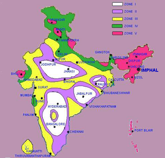
Manipur lies in the very high seismically active zones (Zone V, having hazard levels of the order of 0.35-0.4g) on the Seismic Map of India. The simple design and light materials used in Yumjaos proved that it can effectively cope with the devastating effects of the earthquakes that rocked Manipur time and again. Yumjaos can also be regarded as an efficient semi-natural air-conditioning system!

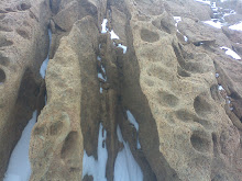
The architectural designs may have its own pros and cons; however, there is no harm in knowing the more than 2000 years-old designs, which is still prevalent in most of the rural areas of Manipur (Figure 1). The questions that need to be asked and answered scientifically are:

  1. Why Manipuri Yumjao or Shangai Sanglen always faced East direction?

Ans: The intensity of early morning Sun is lesser than the noontime because of the slanted azimuth angle. The atmospheric column that the sun’s ray penetrated during morning has greater thickness, thereby, absorbing most of the harmful Ultraviolet-B (UV-B) radiation. However, beneficial Ultraviolet-A (UV-A), which converts to Vitamin D are abundantly present during the morning hours’ sunlight. Sunlight also has antimicrobial properties, which can kill many of the pathogenic microorganisms.

Suppose, if the houses faced North or South directions, most of the beneficial morning sunlight will be blocked by the walls and will not be readily available, unless and otherwise large doors and windows are provided. For mud houses, most of the time it will be damp and a suitable place for microbial propagations.

Houses facing West directions may have some advantages; however, the micro-biocidal potentials are less because of the productions of many atmospheric chemical species during noontime e.g. Volatile Organic Carbons (VOCs), Sulphur Oxides, Nitrogen Oxides, Particulate matters, etc. Evening Sun, therefore, are more scattered and dispersed by atmospheric chemical species, hence less beneficial to human being.

Some of the advantages of houses facing East directions are: (a) pathogenic microorganisms, which reproduced rapidly during nighttime, are deactivated/killed by the morning sunlight; (b) small kids or children need more amounts of sunlight to synthesis Vitamin-D, which will prevent disease like Rickets. Morning sunlight is the most suitable sources of Vitamin-D; (c) as the houses are strategically faced East directions; there is no extra effort to go for sunbathing or sun-drying. The houses will have sufficient sunlight, and it will automatically enter the interior of the houses; (d) during the noontime, when the sun is overhead, the thermal insulations provided by the straws/thatched roof of the houses will make it cool and comfortable and (e) winter Sun’s are slightly tilted towards South; therefore, maximum heat will be absorbed on the southern wall of the house.

  1. Manipuri houses have separate rooms such as Naktha (women handloom place), Mangol (Verandah) or waiting room, Phamen (elders resting place), Ningol Ka (daughter’s Room), Lukhum Ka or Piba Ka (son’s room), Leimarel Ka (mother’s room), Phamen Ka (father’s room), Chakhum Ka (Kitchen) and Sanamahi (family deity) etc. What are the significances for all these rooms?

Ans: The distributions of rooms of the ancient houses of Manipur are well organized into different strategic locations such as Naktha (women handloom place), Mangol (Verandah) or waiting room, Phamen (elders resting place), Ningol Ka (daughter’s Room), Lukhum Ka or Piba Ka (son’s room), Leimarel Ka (mother’s room), Phamen Ka (father’s room), Chakhum Ka (Kitchen) and Sanamahi (family deity), others such as grain storage (Kot) space are behind the houses and as per the requirements. These showed the concept and necessity to provide specifically separate space for different purposes and individuals.

Figure 2. The plans and layouts of different rooms of ancient Manipuri Yumjao/House (Photo courtesy: Ringco Pukhrambam).

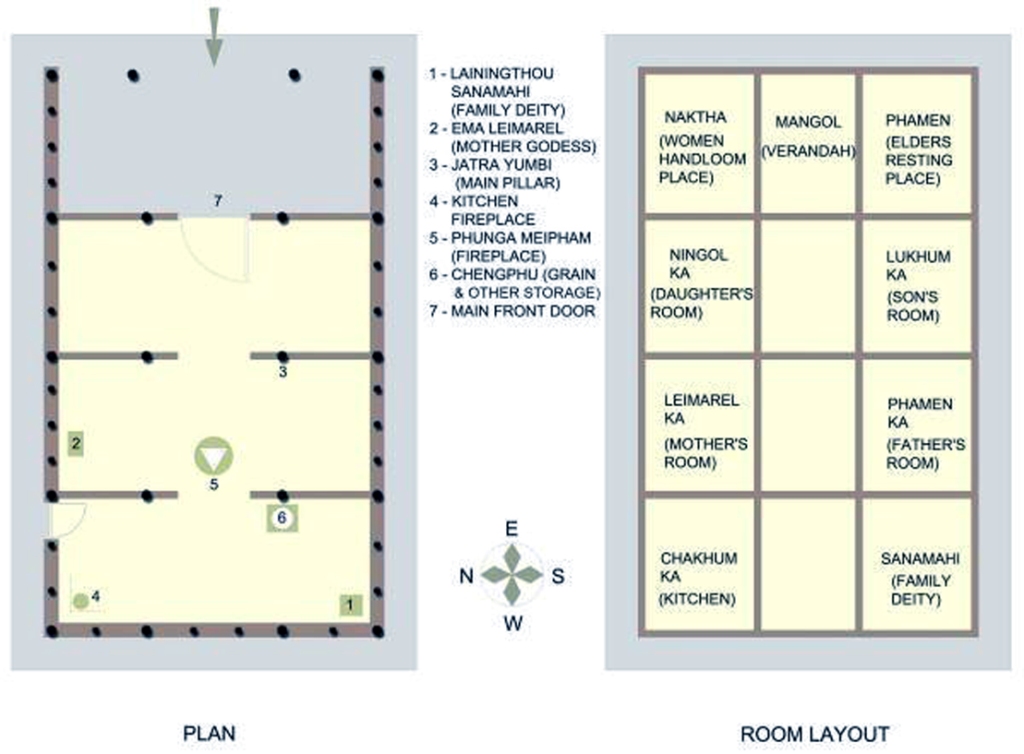
Manipuri ancestors deduced the similarities of the houses with human bodies, i.e. human bodies have different compartments for distinctive organs; thus Manipuri houses have different rooms and compartments for each organ of the family. Ancient Manipuri’s felt that the family members are like human organs, who reside within the compartments of the body of the house. The systematic compartmentalization of the houses also reflects — respect, privacy and identity given to each member of the family and their personal spaces. The origination of our sincerity, honesty, character and culture can be traced to this housing concept, which Manipuri’s are proud-of (Figure 2).

  1. Manipur is prone to frequent earthquake. Is it proven that Manipuri Yumjaos are safer from devastating earthquakes?

 Ans: An architectural design of ancient Manipuri Yumjao/House is shown in figure 3. This design showed that most of the materials used for building Yumjao are light weight materials and mud. The roofs are made-up of thatches and bamboo columns. The joinings are fastened with bamboos splits, and no iron nails or bolts were used. The walls are plastered with mixtures of clay, fine sands, straws, cow-dung and reinforced with bamboo columns in the center. The walls, if not dampened with water can last very long.

Figure 3. The architectural design of ancient Manipuri Yumjao/House (Photo courtesy: Sukumar Haobam).

A major earthquake rocked Manipur-Myanmar border in the year August 06, 1988 at the epicenter of Lat. 25.130 and Long 95.150 and at a magnitude of 6.6 Richter scale. The devastating earthquake does not have major impacts or casualties on the parts of Manipuri.

Figure 4 shows the seismic map of India, where the seismically active zone of the Northeastern Indian Region is included in Zone-V (red color) and is regarded as the highest seismic activities region. Zone V covers the areas liable to seismic intensity IX and above on Modified Mercalli Intensity Scale. This is the most severe seismic zone and is referred to as Very High Damage Risk Zone. An international workshop on “Bamboo housing for earthquake prone areas” held at Aizawl, Mizoram in November 2001, showed that in the cases of houses made from bamboos with modern techniques, can withstand earthquakes in Latin America. The workshop was conducted under the aegis of UNIDO-INBAR and CBTC, was attended by many international experts. Thus Manipuri Yumjaos can be regarded as safe from earthquakes.

Figure 4. Seismic Map of India showing the seismically active zones of Northeastern Indian Region, whih is included in Zone V.
  1. Thatched roofs absorbed more sound than other materials, therefore, reduced noise pollution, is it right? How it can be fireproof?

Ans: Noise pollution is becoming a modern problem with lots of sound producing equipments and instruments used in the households. Normally, concrete buildings and metallic roofs are poor sound proofing materials. However, the porous thatched roofs are excellent sound absorbing or insulating materials. Therefore, in Manipuri’s Yumjaos, the problems of noise pollution are significantly reduced.

Sometime, within two layers of thatches, non-inflammable materials such as sands are sandwiched to make the roofs become fireproof. This technique also provides extra benefits of both fireproof and sound buffering.

  1. Manipuri knew the art of making bricks longtime back, why Manipuri ancestors do not prefer to make living houses by bricks but make temples and religious places by bricks?

Ans: The arts of pottery and bricks making in Manipur are very ancient, however, cementing materials making is relatively new. It would be pertinent to mention here that 16th century architectural designs found in Manipur are made from bricks and cement e.g. Vishnu temple at Bishnupur. Manipuri seems to be more comfortable with the old Yumjaos, because of the various positive factors mentioned in this article.

The rainfall rates in Manipur are very high and making reinforced concrete cement (RCC) roofs are not viable — economically as well as technically. The lifespan of advanced RCC roofs in Manipur are less even with modern methods because of the high rainfall rates. Brick’s buildings are also prone to earthquake and natural disasters. The concrete buildings at the same time are very expensive; therefore, ancient Manipuri may have preferred Yumjao than brick’s buildings.

Temples and religious places, on the other hand, are made of bricks because most of these places are not inhabited by the people. Temples are made from the contributions of the people, therefore, no economic burdens to the individuals. Nowadays, most of the Mandap or gathering places near temple and Manipuri houses are replaced by corrugated tins roofing.

  1. Why there is always a pond in the Northeast directions of Manipuri Yumjaos?

Ans: The possible explanations of Manipuri’s having ponds in the Northeast corner of their front courtyard may be to keep the water clean and uncontaminated. Most of the ponds earlier were planted with flowering aquatic plants such as Lotus (Nelumbo nucifera), Water Lily (Nymphaea stellata), Eshing Ikaithabi (Mimosa nilotica) etc. These plants are very good water purifiers and kept the water healthy. In the past, the sources of water are mainly from the ponds. Almost all the Manipuri’s households used to have ponds in their courtyards. Another advantage of having ponds in the front (Northeast) of the courtyard may be to monitor contaminations or any accident that may occur, especially to children.

  1. Why Manipuri’s used to have bamboo groves (Waapal) on the Western end of their plot of land?

Ans: Bamboos are versatile plants and there are many applications; some of the few examples are energy, fodders and fencing materials. Dried bamboos are used as firewood for various purposes such as cooking and heating. The leaves are used as fodders for cattle and other ruminants. Bamboos are also very good for fencing the boundary of the courtyards. The plants are very tall; therefore, planting it on other directions will block the incoming solar radiations. As mentioned earlier, evening sunlight is not significantly useful, thus the best direction for planting bamboo groves is the Western side of the courtyard. Bamboo groves also act as air filters and blocked high-velocity winds. Due to the various advantages and utilizations of bamboos, Manipuri’s planted bamboo groves, especially on the Western directions of the courtyards.

  1. Sumang or courtyard is kept open, big and large, in front of the houses. What are the pros and cons for this?

Ans: Sumang or courtyard is used as ceremonial gathering or meeting place, where hundreds of people can be gathered in an occasion. The front courtyard is open (without tall trees or plants) to make the house receive plenty of sunlight during morning hours. Sometime, if the Sumang is sizeable; the boundaries are used for home gardening by leaving a large space at the center. It seems that there is no negative impact of Sumang on the houses and to the dwellers. However, due to the increasing populations, diminishing housing lands and skyrocketing land values — the houses are expanding, and the Sumang/Courtyards are shrinking gradually in Manipur.

  1. In ancient Manipuri traditions, some of the tree’s varieties are not recommended to plant near houses. What is the logic behind this?

Ans: Plants produced Volatile Organic Carbons (VOCs). However, it depends on the varieties of plants. Most of the softwood trees produced more VOCs than hardwoods. Trees like Heimang, Pines, Banyan trees are not planted near houses. The VOCs produced from trees and the smoke from household, when combined together causes a ‘synergistic effects’ and become indoor air pollutants. Oak (Uyung) trees are strictly forbidden from planting near houses. These may be due to high iron content of Oak trees, where chances of lightning thunderstorms, striking the tree/s are very high. Almost all tall and large trees are also not recommended to be planted near Manipuri’s Yumjaos. Tall and large trees are hazardous for the houses during high-velocity winds and thunderstorms.

  1. Toilets are always constructed far from the houses, mainly near the Bamboo groves. Was the sanitation of Manipuri poor?

Ans: Earlier, the sanitary systems of Manipur can be regarded as semi-poor. The toilets are mainly pit latrines, constructed near the bamboo groves far from the houses and during the rainy season, it becomes unhygienic. However, the maintenances and servicing of the toilets varied from households to households. Some of the households managed to keep their toilet in a very hygienic and proper manner. The advantage of toilet near bamboo groves is that the transmission of pathogenic microorganisms from poor sanitations is less. The disadvantage is the approach to the toilet during odd hours.

  1. What are the limitations of ancient Manipuri’s Yumjaos?

Ans: Ancient Manipuri houses have certain limitations, which can be improved using modern techniques and architectural knowledge. Some of the limitations that can be highlighted are as follows:

  1. Inability to provide wider opening on walls due to cohesion quality of straw reinforced mud wall and absence of the lintel system, which reduced crossed ventilation and lighting distributions, leading to dark and damp internal space.
  2. Low visibility due to lack of doors, windows, ventilations and partitions of rooms.

iii. Lower quality mud compacted plinth and floor with no proper foundation system could not prohibit the absorption of outside water during the rainy season, making the rooms damp and stinky.

  1. Meitei Yumjao was planned and designed for a single nuclear family dwelling unit with no provision for extension or addition of space for the growth of family members and space requirement.

Optimistically, the above limitations can be overcome by the available natural resources and skillful artisans of Manipur who can modify this indigenous technique with modern architectural designs, to meet the demands of new generations. The combinations of both western style’s designs and indigenous knowledge will be perfect!

Conclusion:

In conclusion, the following points can be highlighted for Manipuris Yumjaos:

(a) The houses are light weight; therefore, the risks to strong earthquakes are less.

(b) Temperature, humidity and pressure control environment are achieved without any further depletion of forest or costly fossil fuels energy resources.

(c) The housing designs are mainly for nuclear family, which make conducive environment for close attachment among members of small family.

(d) As the houses are divided for separate siblings, it gave security to young female members of the family.

(e) The elders are informed on movements of younger members of family passing through a common corridor and door. Therefore, the elders/head of the family has an easy assessment, monitoring as well as control over his/her family.

(f) Ample area/common place or waiting room for gathering of family members and visitors are located at systematic and strategic locations.

(g) The importance or the values of elders in the hierarchy are well placed and preserved.

(h) Interestingly, in some houses, small holes are made on the bamboo pole called “Shemphu”, where coins are inserted as savings by children.

Acknowledgement: The above article is an excerpt from various discussions at the Scientific Manipur (SM), Facebook Group. The authors sincerely acknowledged all the members of the groups for the valuable and constructive comments.

Further Reading: https://kanglaonline.in/2014/11/the-scientific-principles-of-ancient-manipuris-yumjao-house-and-its-courtyard/

WORLD WETLANDS DAY held on 2nd February, 2023

Jointly organised by: Department of Environmental Science, Department of Botany Thambal Marik College, Oinam & IQAC Thambal Marik College, Oinam 

Dr. R.K.Romen Singh Co-ordinator, IQAC Dr. L.Sarnabati Devi HOD, Department of Environmental Science M. Bharat Singh HOD, Department of Botany Prof. Kh. Mohon Singh Principal, Thambal Marik College, Oinam

The Internal Quality Assurance Cell (IQAC), Department of Botany & Department of Environmental Science, Thambal Marik College, Government of Manipur 

Cordially request the pleasure of your kind presence at the “Observation of World Wetlands Day 2023” to be held on Thursday the 2nd February ,2023 at 11:00 a.m at the premises of the College. 

Dr Khwairakpam Gajananda, Associate Professor, Addis Ababa University, Ethiopia 

Prof. Kh.Mohon Singh, Principal, Thambal Marik College, Oinam 

Shri. M. Bharat Singh, HOD, Department of Botany,Thambal Marik College, Oinam 

have kindly consented to grace the function as Chief Guess, President and Guess of Honour respectively. 

PROGRAMME 

11:00 AM 

Assemble of the Dignitaries 

Welcome & Keynote Address by Dr. L.Sarnabati Devi, HOD, Department of Environmental Science, T.M. College, Oinam 

Speech by Dr Khwairakpam Gajananda, Associate Professor, Addis Ababa University, Ethiopia 

Speech by Shri. M. Bharat Singh, HOD, Department of Botany,T.M College, Oinam 

Speech by Prof. Kh. Mohon Singh, Principal, Thambal Marik College, Oinam 

Vote of Thanks by Dr. M.Shomorendra Singh,HOD, Department of Zoology, Light Refreshment

THAMBAL MARIK COLLEGE, OINAM, MANIPUR 

World Wetland Day 2023 https://drive.google.com/file/d/1jQlPGiGcQUl9D1-qlZO5SSHg9qxTG88l/view?usp=drive_link

WWD Thambal Marik College https://thambalmarikcollege.ac.in/wp-content/uploads/2023/02/WWD.pdf


Tuesday, March 12, 2024

SEROU--EMA NUNGTHONG SIDABI. MESMERIZINGLY BEAUTIFUL PLACE IN MANIPUR. THE PLATINUM DEPOSITE SITE.

SEROU--EMA NUNGTHONG SIDABI.

MESMERIZINGLY BEAUTIFUL PLACE IN #manipur. The place is believed to be the place of #platinum deposit site by various #geologists.

Various Platinum containing rocks are found in this location, such as #chromite and #olivine rocks. Smooth and dark eroded #serpentine rocks are also found in the river beds.

The place is famous for the very nutritive and proteinaceous algae like #spirulina called Nungsam in Manipuri and botanical name Lemanea australis Atkins.

The place is mythologically significant that three (3) doors were bolted by 3 large iron rods by the divine principalities of Manipur. Eputhou Khana Chaoba Wangpurel (Wangbrel) of #sugnu is also located nearby.

Out of the 3 iron rods, only one is found, 2nd one is inside the river bed and the 3rd one vanished from the site. Never to be found.

The doors are viz. 1. The Living Door (Achang Thong), 2. The Death Door (Asi Thong) and 3. The Earthly Door (Malem Leisa Thong).

Santidas Gosai tried to open the Asi Thong (Death Door) at #serou, but he failed miserably.

After the #kuki #meitei Manipur ethnic violence of May 3, 2023, the place is closed for the time being.

The #video was taken during Manipuri Calendar, Wakching Purnima (January 2023) and Feiren Purnima (February 2023).

PLEASE LIKE, SHARE, SUBSCRIBE AND COMMENT. 🙏

Video: https://youtu.be/l4GVNeAps0A?si=ilAmGE8N-kU6C2E3

Friday, July 25, 2008

Is Antarctica a future target for Man??

Antarctica is known to be holding 75% of the total world’s fresh water in the form of 90% ice. To hold, this water in a healthy state of hygiene, it has a natural cooler, otherwise, water would have developed bacterial counts, much higher than probably, we can consume. Also, the loss of this water in the form of evaporation is compensated by the fresh snowfall, so that it maintains itself. The beauty of this fresh water is that, Antarctica is not holding this water in a deep well or pond or a pit or lake; it is on the top of gently increasing slopes of a huge dome. Probably nature has kept it in this fashion, so that man can use it, as and when required.

Antarctica is a gigantic freezer with its doors open to the southern hemisphere. Since its doors are open, it transports cold in the form of air out flowing from the interior of the continent to the periphery; water melted from polar cap ice and the shelf breaking in the form of ice bergs. The transport of cold is probably to keep the biological life in the Antarctic ocean as full of proteins , fat and fresh for consumption.

The biological reserve that has already been exploited by the man is the biological life in the ocean. Whales and seals were killed for various reasons and to such an extent that today, many nations had to declare them as "endangered species". Now, man has focused its attention on krill-the stock of food is very well known. The use of Antarctic bacteria for bio-sciences applications is another reserve.

Apart from these two apparent resources, it is the hidden resources which are now being looked at and as assessment is being made.

Antarctica is attaining great importance, as a possible source of minerals, oil, coal etc. However, at the moment, the exact resource potential and economics, may be the limiting factors, but with the technological advancements, days are not far off, when mining, off-shore oil drilling etc may be a reality in Antarctica.

Antarctica formed a part of the super Gondwana continent about 200 million years ago. Australia, India, Africa and South America were part of this Gondwana continent, which slowly drifted apart after Gondwana fragmented. Landmass of Antarctica, which covers an area of about 14.5 million sq kms, is about 3.2 to 3.6 billion years old, covered by rocks of relatively younger age of sedimentary, plutonic and of volcanic origin.

Therefore, since, India, Australia, South America and Africa have deposits of mineral wealth, it is therefore, believed that the Antarctic continent must have these deposits in large quantities, but here everything is underneath, the thick polar cap ice. In fact, it is the thick polar cap ice, which has restricted, the exact assessment and exploitation of minerals, but everyone is curious to know, what kind of deposits are there and what could be our share, if such an exploitation becomes, a reality.

Until 1970s, the expeditions were mainly for Scientific purposes, but with the ever increasing pressure of population, energy and economical needs of the countries, several nations have taken interest in Antarctica's mineral resources. Of course, the assessment of Antarctic mineral resources at the present stage is based on geological analogies and reconnaissance evidence.

The Antarctic Peninsula is easily accessible and thus has been studies, well. The modern technique of hydrocarbon resource assessment using sedimentary basin has suggested, petroleum potential of Antarctica. Oil is one of the minerals, which is going to attract many nations and the technology for off-shore oil drilling is not new to the world, and world, would see, its use even in Antarctica in the century. It has been estimated that 45,000 million barrels of oil and 115 trillion cubic feet of gas may lie, off shore the Antarctic coast.

Of course, while making any off-shore drilling, the natural gate keepers of Antarctica, technology will have to be developed to tame the natural gate keepers of Antarctica-the Ice-bergs.

Coal seems to be available in varying quantities and coal belts have been postulated under most of the east Antarctica's central ice sheet. It is believed that coal deposits many be around 11% of the total coal deposits of the whole world.

Among the other minerals, mica, quartz crystals, iron and many other ores are also available.

The exploitation of any particular mineral deposit in Antarctica will depend on its type, size and location, as well as, the environmental factors. At the moment, minerals of high value like gold, platinum, nickel, uranium will get the priority.

Although, mining at the moment is banned, United States environmental groups were the first to oppose the potential opening of mining and oil drilling in Antarctica, it has now been signed by all the member nations of the Antarctic treaty.

It is in fact the Antarctic treaty which has kept the continent free of conflicts, but the human pressure is increasing due to the scientific and tourist activities. The treaty bans mining in Antarctica for a minimum of 50 years and designates the whole continent and its dependent marine eco-system as a natural reserve devoted to peace and science.

Sunday, May 18, 2008

LARSEMANN HILLS OF EAST ANTARCTICA

Larsemann Hills is at the Ingrid Christensen Coast of east Antarctic region (69O 24’ 28.8” S latitude and 76O 11’ 14.7” E longitude). It is named after Mr. Larsemann Christensen and is an ice-free coastal oasis at the Prydz Bay, located approximately midway between the eastern extremity of the Amery Ice Shelf and the southern boundary of the Vestfold Hills. The Prydz Bay represents an embayment along the Eastern Antarctic margin, lying between the East Longitudes 660 and 790. The Amery Ice Shelf on the southwestern side and Ingrid Christensen Coast on the southeastern end define its limits. The isolated islands, promontories, peninsulas and nunataks occurring along the continental ice describe the rocky terrain exposed in the area, which, from east to west, fall under Vestfold Hills, Rauer Group, Larsemann Hills and Bolingen Islands respectively.

There are two main peninsulas on the two extremities of the Larsemann Hills, namely the Broknes Peninsula and the Stornes Peninsula. In between these two peninsulas, there are number of islands of varying dimensions and some unnamed promontories. The northern and western sides of Larsemann are dotted by a series of small islands. The satellite imagery of the area indicates open sea on the eastern edge of the Broknes Peninsula. Westwards, the Clemence Fjord separates Broknes Peninsula from Stinear Peninsula and Fisher Island. The area north and westwards is marked by a number of islands, namely Harley, Easther, Breadloaf, Butler, Betts, McLeod, Jeason, Solomon, and Sandercock Island.

The area is marked by persistent, strong katabatic winds that blow from the north-east on most summer days. Daytime air temperatures from December to February at times exceed 4˚C, with the mean monthly temperature a little above 0˚C. The area generally remains snow free. Snow cover is generally deeper and more persistent on Stornes Peninsula than Broknes Peninsula and the present site.

There are several freshwater lakes ranging from small ephemeral ponds to large water bodies. Some of these water bodies are briefly ice-free or partially ice-free in the summer months. For the remainder of the year (8-10 months) they are covered with ~2 m of ice.

The highest elevation on Larsemann Hills is around 180 m above sea level. The hills are dissected by steep valleys lying between the ice sheet and the coast. The area is devoid of any higher organism and plants except for some sea bird, seals, penguins, algae, lichen and mosses.

Thursday, May 15, 2008

ANTARCTICA

In the middle of the summer daylight
When the world glows by the sunlight.
Peeping out through the window
I could see the beauty of the shadow.

The gouging ‘Sastrugis’ flows
The colorful ‘Algae’ grows,
The sluggish ‘Seals’ are slow
While the gentle wind blow.

The mighty ‘Whales’ goes
Ignoring the unfriendly foes!
The careful mother nurture
Creating the child a future!

The black coated ‘Penguins’ crawls
Nourishing its chicks with Krill’s.
And the brown ‘Petrel’ flapping lower
I could see from the tower.

The summer sun goes down
The early ‘Skua’ will come at dawn.
If you run through the fallow
You’ll be followed by the shadow.


The stillness of this night
Was awakened by the whistling of the wind.
The harmony of this moonlight
Was aroused by the rattling of the ‘Blizzard’!

Lustrous stars are shining
Dazzling ‘auroras’ are glowing,
And the tired bodies relaxing
Though the darkness never ending.


But the courage that we have,
And the strength that we save,
The commitment that we gave,
Will unite the spirit of our brave!


All the icy deserts are dry,
All the ‘Nunataks’ are high.
And all the birds will fly,
But if you rely!
Antarctica will smile!

Sunday, May 11, 2008

WILL MAN MADE IMPACT BE FATAL IN ANTARCTICA?

Man has already proved that unchecked, unregulated exploitation of seals and whales have indirectly taken many other species of organisms to the endangered levels. This means, what constructive work nature did in millions of years, man was able to destroy just in couple of decades.

Today, with technological advancements, the danger to nature has grown to such an extent that man has been able to make estimates of minerals and oils, hidden by nature under the thick sheet of ice. If the mineral exploitation is permitted in Antarctica, it will not only load the environment with dust, it will also lead a large icy area to reduce its albedo. The reduce albedo will enhance melting of the ice sheets to such an extend that the sea level will rise more than 1 metre.
In fact, Antarctica is a fragile eco system of ice-air-ocean-energy, in which if one component is affected, all others will also be disturbed. Therefore, many countries try to protect Antarctic environment seriously, raise the issues of sovereignty, politics, logistical convenience, financial considerations, and the facilitation of scientific research. Environmental groups are, therefore, concerned about the scope of procedural and informational requirements for reviewing proposed projects and regulating development activities, especially in light of potentially large financial and political incentives associated with minerals development. Liability for environmental impacts from serious accidents is also an issue.

The way, world population is increasing, the hunger of the world for energy, food, water and other life support materials may modify the environmental treaty (Antarctic Treaty), in which, instead of maintaining pristine environment, only a practically clean environment may be maintained. This will be an extremely dangerous situation, as practically clean sampling and monitoring will not be feasible in such a harsh environment and thus the procedure will violate the treaties. The people who does not adhere to the protocols will be penalise and thus the conflict will erupt. Toady, the example at the world level is the pollution levels of various gaseous and solid pollutants in major cities which are often beyond the acceptable limits, yet nothing is done. Or many times, the monitoring approach remains only a paper work and nothing in reality is implemented. Often the monitoring and legal machinery is so corrupt that one is left to spoil the environment as much as one likes, just on the basis of economical power to grease the hands of these agencies.

If minerals development proceeds within the framework of the Minerals Convention, future debates will likely focus not on decision making procedures, but on the definitions of the Convention's many qualitative terms such as "adequate," "effective," "acceptable," "significant," "safe," etc. These terms can only be defined within the framework of scientific knowledge and uncertainties about Antarctica's environment.

Similarly, oil exploration, oil spillage from tankers, oil fires etc may deposit a thin film of crude oil seriously affecting the marine life and its entire dependent food chain. The third and the most critical factor which will affect Antarctica is the exploitation of Antarctic ice for meeting the need of world's drinking water for the growing population. As the world is witnessing the water shortage and the III world war to be fought for oil, water and food, will human start looking for pure, clean, ready to drink water from Antarctica? If so, who are responsible? Can we stop it? Or is it good to bottle water from Antarctica and serve it in the 5-Star Hotels?

Tuesday, April 22, 2008

Monday, April 21, 2008

CONVECTIVE CURRENT DISPERSE MICROORGANISM: EAST ANTARCTICA

The Indian Antarctic station, Maitri is in the Schirmacher oasis of east Antarctica. The oasis is covered with snow/ice; except for the local summer season when it gets deglaciated and exposes the small hilly region. During summer, minute microorganisms are observed near water bodies of this rocky terrain. In the year 1996a monostatic acoustic sounder probed planetary boundary layer dynamics over this region. From the data it is observed that the thermal convection (both free and forced) persist for 5.63% of the time in the whole year. The occurrence of free convection predominates in the local summer season around midday, while sporadic cases of forced convection have been recorded during the autumn and winter seasons. The onset of convection is mainly at 0600 hrs to 1200 hrs, while the cessation period is limited within 1400 hrs to 1900 hrs. The cessation of convection is basically governed by the katabatic wind flow around the Schirmacher region and it indicates that the interior of Antarctica or the polar cap ice becomes cooler much faster than the rocky region of Schirmacher oasis.

Examples taken from the literatures on atmospheric structure and their effects on dispersal of microorganisms and their distribution by the wind are discussed. The study of monostatic acoustic sounder for thermal convections/plumes may form input for the study of dispersal, survival, metabolic activities and dispersion model of microorganisms. The application of convection/plume to aerobiology can also lead to improvements in forecasting, monitoring and understanding the various mechanisms of organism dispersal.

For further reading please refer:

Saturday, April 19, 2008

Land use and land cover changes Himalaya

Land use and land cover changes that occurred during the period from 1991 to 2001 in the Jahlma watershed of the Lahaul valley, a cold desert region of the northwestern Himalaya, were evaluated using land use data and visual interpretation of IRS Satellite imageries. The results revealed that out of the six major land use forms within the watershed, land areas under agriculture, kitchen garden and settlement land were found increased, whereas a declining trend was recorded in areas under grassland, barren land and Salix plantation. The cultivated land within the watershed increased from 54.87 % (total of agriculture land, kitchen garden, grassland, barren land, Salix plantation and residential area) in 1991 to 56.89 % in 2001, corresponding to an expansion of 4.41 ha. On the other hand, the areas of grassland decreased from 31.41 % in 1991 to 29.81 % in 2001. Such a dramatic land use and land cover changes taking place within the 33 km watershed area in a single decade clearly indicates the prevailing danger of land degradation and environmental deterioration in the region.

For further reading please refer: 

Aerosols behaviour: Northwestern Himalaya

Total suspended particulate (TSP) matter on fortnightly basis throughout the year and mass size distribution of aerosols as well as ultrafine aerosols on weekly basis in the months of May and June were monitored during 1996-2003 at different altitudinal locations of the Kullu-Manali tourist complex in the northwestern Himalaya. Concentration of TSP ranged from 35.8 (August 1996) to 207.3 µg m-3 (June 2003) at Mohal [1150 m from average sea level (ASL)] and from 31.7 (July 2003) to 239 µg m-3 (April 2001) at Manali (2050 m ASL). The mass size distribution of aerosols showed a bimodal distribution having one peak in the coarse size range (3.3-9 µm dia) and the other in the fine size range (0.08-2.1 µm dia) at both the locations. Ultrafine aerosol (UA) (0.001-0.1 µm radius) concentrations were found to be highest at the lowest experimental altitude site (Mohal) and vice versa. The diurnal variation of UA concentration for three years showed that the concentration ranges from 2640 (at 0500 hrs LT) to 5160 Number (N) cm-3 (at 1300 hrs LT) at Mohal and from 400 (at 0400 hrs LT) to 2190 N cm-3 (at 1300 hrs LT) at Kothi. On an average, TSP crossed its permissible limit set by National Ambient Air Quality Standard (NAAQS) level in the sensitive areas such as Kullu-Manali hill spots. Bimodal nature of mass size distribution indicates two important sources contributing in total aerosols—the fine mode, primarily due to anthropogenic activities and the coarse mode aerosols, mainly due to natural sources. Large number of concentration of ultrafine particles indicates the presence of air pollutants more at low altitudes as compared to high altitudes.

For Further reading please refer:

Himalaya: Increasing Aerosols

Total suspended particulate (TSP), size-separated atmospheric aerosols and aitken nuclei (AN) were monitored at Mohal (Kullu) and Manali tourist complex, in the northwestern part of the Himalayas from 1996 and onwards. Long-term trend analysis for TSP indicated a significant increase since January 1996 to December 2003 at Mohal (P<0.05) and at Manali there is no increase in the TSP level (P=0.9). The results indicate that the eight years average concentration of TSP at Mohal is 78.4 μg m−3 and 66.9 μg m−3 at Manali. Seasonal average shows that the TSP is highest during summer (Mohal 90.3 μg m−3, P=0.2; and Manali 74.1 μg m−3, P=0.5) followed by winter season (Mohal 84.3 μg m−3, P<0.05; and Manali 71.0 μg m−3, P=0.7). The mass size distribution of aerosols showed bimodal distribution having one peak in fine mode (0.08–2.1 μm) and the other in coarse mode (3.3–10 μm) at both the locations. The highest value of fine size separated aerosol showed the maximum values at 0.43 μm mode. AN (0.001–0.1 μm) density shows fine particles of air pollutants more at low altitude as compared to high altitude. The diurnal variation of AN showed maximum values between 1100 and 1400 h. The daily average concentration of AN at Mohal, Manali and Kothi was found to be 3990, 3200 and 1350 N cm−3, respectively. The increasing trend of TSP, high value of size separated aerosols in the fine mode and the peaking of fine particles during noontime are the indication of rising air pollution due to anthropogenic activities in this region. 

For further reading: 

Thursday, April 17, 2008

East Antarctic: Ecosystem

Based on the collections of vegetation from 14 sites by line transects in the Schirmacher oasis (SO) of east Antarctica, a total of 24 species consisting 12 species of lichens, 7 species of algae and 5 species of mosses were recorded. The algal flora consists mainly of phytoplanktonic groups dominated by blue green algae cyanobacteria such as Oscillatoria limosa and Phormidium fragile. Only one green alga (Chlorococcum) was found in the present transect study. Rare occurrence of green algae and dominance of blue green algae in the SO suggests that cyanobacterial species are better adapted to the prevailing extremities of climatic conditions of Antarctica. Bryum argenteum dominated the moss species and Acarospora gwynnii dominated the lichens. The plant community of the SO is heterogeneous in character, where none of the species approach 80-100% constancy, suggesting an unsuitable habitat for any species to occur homogeneously. The heterogeneity of vegetation can be linked to microenvironments of the oasis, which might have provided a little congenial condition for growth, both spatially and temporally during the austral summer. The estimated standing crop (dry weight) or biomass per square meter of SO varies from 6.25 to 45.31 g m-2 in various study sites and the average value is 22.5 g m-2.

For further reading please refer: 

East Antarctic: Organic Carbon and Enzyme

Schirmacher oasis (SO) (70°46'04''S to 70°44'24''S; 11°49'54''[+/-48]E to 11°26'03''[+/- 02]E), one of the smallest oases in Antarctica, is situated on Dronning Maud Land, which is about 70 km south of the Princess Astrid Coast of east Antarctica. This oasis is a small rocky moraine, surrounded by the vast polar ice cap and Antarctic ice shelf. It represents cold desert conditions, devoid of any higher plant and animal life, except for a few patches of microbiotic crusts in some suitable niches. Melted water from glaciers, ice and snow produces about 30 fresh water lakes and many streams, which supply essential nutrients to the autotrophs (algae, mosses and lichens). Between 30 December 1999 and 29 January 2000, soil samples were collected from 14 sparsely vegetated sites to study the soils and ecology over this oasis. Bio-physicochemical parameters, organic carbon and microbial activities (dehydrogenase) of the soils were determined. The average surface air temperature and wind velocities during the sampling period were -0.87°C and 4.3 m s(-1). The average pH, plant biomass (standing crops) and moisture content were 7.5, 22.5 g m(-2) and 375.4%. Total organic carbon (TOC) contents of the soil samples ranged from 1.16 to 2.58% and the mean value was 1.58%. Dehydrogenase activity (DHA) was low and the average was 0.008 mg Triphenyl formazan (TPF) g soil(-1) day(-1). The low DHA in SO suggests that anaerobic oxidation of organic C is poor. TOC and DHA are negatively correlated with plant biomass (r= -0.14, P= 0.62 and r = -0.21, P = 0.48). The organic C and microbial activities are dependent on the amount of the autotrophic productivity and abundances. TOC correlated significantly with DHA (r = 0.85, P less than 0.001), which indicates that organic C is an important factor in controlling the development of DHA in the SO. The averaged bio-physicochemical data in the oasis do not deviate much from the respective mean values and the TOC is expected to remain in the range of 1–2%; however, a small change in human activity is likely to cause long-term impacts in this pristine ecosystem.

For further reading please refer: 

East Antarctic: FOG

An episode of fog during 8–9 January 1996 over the Schirmacher Oasis of East Antarctica was investigated. It revealed that the fog was formed due to advection of southeasterly winds by high moisturecontaining northwesterly winds, blowing from the ocean over the cold ice shelf, which leads to the condensation of moisture, thereby forming fog for a duration of about 24 h. A monostatic acoustic sodar recorded the episode, which revealed the thickness of fog layer up to an altitude of about 300 to 400 m. Supplementary meteorological and radiosonde data were utilized to understand the mechanisms of the formation and dissipation of advection fog in this region. Supporting literature illustrates that this type of fog is an important source of water for photosynthesis, growth, reproduction and other metabolic activities of the poikilohydric microbiotic crust inhabiting the cold, arid and dry ecosystem of the coastal East Antarctic oases.

For further reading please refer: 

Tuesday, April 1, 2008

Large Iceberg and diminutive Emerald Sea behind

Ice-bubble formation after lake water freeze

ENVIRONMENT OF ANTARCTICA

We stand at the threshold of a major change in our approach to environmental issues Antarctica, the coldest and the windiest place in the world is now a source of endless concern and controversy. It is unique in every sphere and is a common heritage of all the human kind. Politically, it belongs to every country in the world. Biologically, it is the largest wildlife sanctuary on the earth. Ninety percent of the planet’s freshwater resource is located here. The continent is a critical component in the world’s weather system and an invaluable open-air laboratory for monitoring global atmosphere pollution. Antarctica is the only continent, which is virtually unspoiled by any anthropogenic action. Scientifically, Antarctica can be look as a unique open system of the earth, where all the life, geology, climate and water interact to each other over the millions of years, converge to produce a occurring pattern of changes that has profound effects on the regional and global environment. It is also a part of the planetary energy system, receiving from the Sun, undergoing changes, affecting life, oceans, atmosphere, climate, and sediments. In this energy system Antarctica plays as a heat sink. Energy flows continuously from the source (the Sun) to the Earth and to the sink (the Antarctica). Applying the laws of thermodynamics, all the energy received on Antarctica is conserve in the form of glacial ice. Therefore, 78 percent of the world’s glacial ice are locked here. In biological ways, it can also be seen as a vast single ‘ecosystem’, where the dynamic complex of all the endemic organisms and its local non-living environment interacts as a single functional unit. Hence, it is a unique system. "Biogeochemical cycle" or the movement or cycling of a chemical element or elements through the earth’s atmosphere, hydrosphere, lithosphere and biosphere plays a significant part in determining the bio-diversity of an area. In this cycles the biota plays a key role for exchanges of vital nutrients from one phase to another. Some of the micro-nutrients (carbon, hydrogen, oxygen, nitrogen, phosphorous, sulphur, calcium, potassium, iron and magnesium) that form the major building blocks of the organic compounds and which are required in large amounts by most forms of life are continually circulated by the organisms. In the case of Antarctica as there is very less diversity of flora and fauna this cycles are not so profound. Although, other related cycles which are performed by he non-living environment such as ‘the sedimentary cycle’, ‘the tectonic cycle’, ‘the hydrologic cycle’, ‘the rock cycle’ etc. are more or less pronounce in this continent. The weathering and erosion of nutrient rich rock from the Antarctic continent by the glacier and the wind activities makes Antarctic ocean to be the most nutrient rich ocean in the world. This makes the southern ocean to be the most biologically productive ocean in the world. Although, Antarctica has the harshest environment due to extremely low temperature (average –45o C) and high wind speed (average 100 km), the continent has been continually exploited by humans after the events of modern industrialization. During the early 19th century most of the biological resource and the tranquility of the continent has been disturbed by human beings either for commercial or scientific purposes. International interests on Antarctica began with commercial whaling and sealing expeditions through the 18th and the 19th centuries. Now Antarctica is no more isolated continent but a vast natural laboratory for humans. The fate of Antarctica is day by day at the mercy of human beings. Although industrialization has brought many benefits to human kind, the impact on the environment is never a positive one. As the world’s human population increases exponentially and the resources become scarcer everyday, the governments and businesses are looking to Antarctica for new supplies of food, freshwater and mineral wealth. The worldwide problems of malnutrition and protein deficiency further look forward to the exploitation of protein rich "krills" population in the Antarctica Ocean, which will further disturb the intricate Antarctic Ocean ecosystem. Impact of green house effect and global warming with the resulting affect of sea level rise due to melting of Antarctic ice are becoming more and more serious environmental issues today. The environmental health problems due to ozone depletion and the effect of harmful UV radiation are also a major concern now. Therefore, Antarctica has become a central consideration of human environment and is becoming one of the greatest environmental issues of the world.

THE FATE OF LOKTAK LAKE

Manipur the ‘Jewel of India’ or the ‘Switzerland of the East’ has so many peculiar features. Endemic plants, animals and scenic beauties regardless of any exaggeration, will always be pristine. The state which lies between the 230 80’ N - 250 68’ N and 930 03’ E - 940 78’ E at the North East extreme of India, nestling at an altitude of about 790 m above the mean sea level was guarded naturally by nine ranges of hills.

Although, Manipur is a small state (area = 22,327 Sq. Kms), the species endemism are surprising large. The climate, topography, and geographical conditions are somewhat different from the rest of the world, determining the large number of biological diversity in this state. Adding more to its beauty like a sparkling diamond amongst the pearls, a beautiful lake known as “Loktak Lake” shines at the center of the state. Loktak (LOK = stream + TAK = the end) is the journey end of several streams and rivers. It is also a pulsating lake, which is about 500 Sq. Kms during rainy season and 250 Sq. kms during winter and is proud to be the largest fresh water lake in the northeastern region of India. The cultural and the traditional aspects of Manipuris will never be completed without relating this lake, which has been witnessing the whole history from the beginning of the Manipuri civilization. “Moirang Kangleirol” among the various examples is still remembered till today.

This lake is inevitable to the communities of Manipur. Loktak Lake is becoming very important in terms of its socio economic value, environment, cultural, tourism, habitats of numerous waterfowls, plants, animals, fishes, its dynamic ecological system, potential natural resources etc. were all becoming indispensable to the people of not only Manipur, but also to the world. The first international concern of this lake was in the year 1990 in which “the Convention on Wetlands of International Importance” drafted at the Iranian City of ‘Ramsar’ (1971) gives full emphasis of the Loktak Lake for its peculiar characteristics. This convention simply known as “Ramsar Convention” thereby brings the Loktak Lake into the international status for its uniqueness and put into the limelight for its conservation and management Out of the 18,37,149 (as per 1991 census) populations of Manipur about 12 Lakhs people are directly or indirectly benefited from this lake. Foods, agriculture, irrigation, pisci-culture, energy, aesthetic and recreational values are exploited by the people since time immemorial. Thus, the exploitation of the various renewable and nonrenewable resources decides the socio-economic condition of the state. During the 1979 Manipur famine, the fruits of Trapa bispinosa/Trapa natans (Heikak) and Euryale ferox (Thangjing) were the only sources of livelihood for thousands of people. Just two decades back, the biodiversity of Loktak Lake was very rich in its floristic and faunistic value. However, today, the most important fauna of this lake, the Brow-antelered deer or Cervus eldi eldi (Sangai) is at the verge of extinction. Efforts are made by the government, voluntary organizations, and individuals to conserve this priceless deer species from extinction. In 1977 the Indian Board of Wildlife gave ‘Keibul Lamjao’ the status of a national park. A recent survey of the Loktak Lake revealed many of the undesirable factors, which we have been avoiding till today, either knowingly or unknowingly. An attempt to make the decision-makers aware about the fate of this lake has been put forward in this brief report. The major issues are as follows:

1. Waste products brought by the rivers
Nearly 29 to 30 rivers and streams feed Loktak Lake. ‘Ungamel Channel’ (Ithai Barrage) is the only outlet for this lake. The perennial rivers and streams, which flow into Loktak Lake, bring sediments every day in their course to the lake. Continuous soil erosion in the hilly terrain due to deforestation further enhances the process. The sediments deposit at the mouth of the rivers contributes to shallowing of the lake bottom. As most of the rivers flows in the heart or center of the cities and towns, the urban sewage dumped into these rivers ultimately reached the lake, whereby contributed in deteoriating the delicate ecosystem of the lake. Highly toxic substances such as insecticides, pesticides, oils, polythene bags, other non-biodegradable waste and municipal wastes further create a disastrous situation to the lake environment. “Nambul” river the most polluted river in Manipur ends up in this lake after depositing whatever possible pollutant it bring in its course. “Thongjaorok” or Bishnupur River on the other hand brought its entire sediments load, cause due to mass deforestation in the upper part of the hilly region of this river.

2. Soil erosion at Thanga Island
Today the face of “Thanga Island” has become scared by both natural and anthropogenic actions. Among the natural causes are the wind, waves, rainfall, and weathering of the rocks. This phenomenon was greatly enhanced by the human intervention, to fulfill the needs in an unsustainable manner. Various activities such as road construction, housing, playgrounds, schools, clubs, theatres etc. are degrading the environment of this island at its utmost level. Circular road constructed around this hill island by cutting trees and the sides are making unaesthetic and erosional features. Control measures over this highly populated hill island is out of question and it will remain unrestored, witnessing its dwindling environment helplessly, till it submerge into the lake!

3. Floating huts or Phumshang
Although a traditional way of living and a unique feature of Loktak Lake created by the local fishermen, “floating huts” or “phumshang” has disrupted the environment of the lake. As the population of the fishermen increased the number of phumshang also increased manifold. Now the huts can be estimated upto 2000 in number. Various plastic ropes, heavy rocks, woods, bamboos, zinc plates, iron rods etc. were use to construct the huts. Numerous pesticides and insecticides are also used for catching fish or as insects repellent. The live of a phumshang can be estimated upto 20 years, after that it sinks into the lake causing all the possible environmental degradation it can result! The main concerns of phumshangs are the formation of vertical profiles of the lake water body. The phumshang, which was made by accumulating hydrophytic plants, rocks, woods, bamboo’s, plastic ropes etc. blocks the sunlight to enter into the water. The lower portion of the floating hut decomposed and sinks down on the lake bottom, which is termed as “benthal”. The decomposed materials of benthal released toxic gases like methane, H2S, etc. dissolving the oxygen and making the water septic and polluted for the aquatic plants and animals to survive. The layer above benthal, which is a dead water zone, is called as “hypolimnion”. Above hypolimnion, a thin layer termed as “epilimnion” is the only place for some game fish to survive. In this zone, very little penetration of sunlight allows aquatic plants to grow and local fish to survive. Today, the benthal of Loktak Lake has become increasingly thick, which not only pollute the lake water but also contributed largely in shallowing the lake.

4. Extinction/Loss of indigenous species
Introductions of new and alien species of animals or plants are sometime drastic to those introduced habitats. Some of the best examples are the introduction of rabbits in Australia and pigs in Mauritius. These two animals had caused all the possible destruction in these two island nations. In Australia all the vegetation’s and crops destroyed and the population of rabbits increased astronomically, so the Government declared it as pest. Whereas, during the 17th century in Mauritius the Dutch introduced pigs’ breaks down all the eggs of the flightless bird called “Dodo”, now dodo is extinct (since 1692) and can never be seen in this world. Similarly, during the 80s the Government of Manipur had introduced many species of fishes, amphibians, insects and plants into the Loktak Lake without any concerns about the future consequences of the introduction of new and alien species. Among these are the grass craps, silver craps; insects like Weevil species (Neochetina eichhornia and Neochetina bruchi) etc. These have causes many perturbations to this lake ecosystem. Bottom-feeding rough fish stir up sediment, which released phosphorus. Indigenous species of fishes, plants and animals are rarely seen now. Earlier, during the 60s and 70s the lake was decorated with Nelumbo nucifera (lotus), Nymphaea stellata (lily), Alisma plantago (Kakthrum), Sagittaria sagittifolia (Koukha), Setaria pallidefusea (Kambong), Oenanthe javanica (Komprec), Alpinia galanga (Pullei) etc. but today where has it all gone? Once Loktak Lake was a playground for the local fishes like Channa punctatus (Ngamu), Anabus testudinius (Ukabi), Anguilla (Ngaril) and other locally known fishes such as Pangba, Tharak, Ngashap, etc. These fishes have now cursed the human being and surrendered to its rivals (introduced fishes) and slowly leaving its own home! Why it happens to our beloved Loktak Lake? The answer is we forgot to conserve our precious lake in a sustainable ways. The competitions amongst the introduced fishes and the local fishes, clearance of the breeding sites of the local habitats, water pollution, blockage at the Ithai Barrage dam for the periodic spawning fish to swim upstream, eutrophication and the menace of Eichhornia crassipes (Kabokang), stratification of the lake, over fishing etc. are the major culprits. Recent out break of the fish’s disease ‘Holo-ulceritis’ or UDC (ulcerative disease symptoms) was all due to highly polluted water body. The victims of this disease were mainly the indigenous fishes. The famous endangered Cervus eldi eldi (Sangai) is now at the mercy of the ruthless human being and the fate of extinction is knocking at the heaven’s door! Strategies to preserve Sangai were framed, rules and regulations are made, various do’s and don’ts were put into force. But the sad part is that the population of Sangai is always at the danger mark. This is because the authorities do not realize the actual meaning of ecosystem preservation. It is that the small plants, animals, birds and the microorganisms, which are more vulnerable to human perturbations. They interact with their nonliving environment to make sustain and survive this valuable Sangai and what else, we human being too! Therefore, the conservation of the minute plants and animals, also the physical and chemical environments are more or less important like we do for our Sangai. Today, we are witnessing the failures of the conservation strategies of the government, which is likely to be continued in the near future also. The victims will not be our Sangai but it is our coming generations that will live grievously by the betrayal of their ancestors.

5. Water pollution
Detergents, soaps and other phosphates and nitrates containing chemicals, which brought down by the rivers to this lake cause ‘eutrophication’ of the lake. In this process algal blooms started and compete with other aquatic plants for light and nutrients. These blooms release toxic chemicals killing aquatic plants, animals, and birds and deplete oxygen; thus water begins to stink. As the water body is lentic, the decomposed organic matters remain in the lake for a very long time. Use of chemical weedicides, rapid accumulation of weeds near the lake shores, use of pesticides and insecticides, chemical fertilizers, and other non-biodegradable substances are all the factors for causing the lake water polluted.

6. Shallowing of the lake
As mentioned in Section 1, nearly 29 to 30 rivers and streams feed the Loktak Lake. The incoming rivers and streams brought sediments and dump it into this lake. The outlet (Ungamel Channel) removes only the excess water and practically no sediments. The depression is fill up with sediments and in course of time converts into terrestrial landform. The process is known as ‘Hydroseric Succession’. Therefore, the life of all the lakes is not permanent. The Loktak Development Authority (LDA) decisions of dredging the lake bottom are too fast. The officials should understand the ecological perturbations and the future consequences. They should adopt a comprehensive Environmental Impact Assessment (EIA) report. The decision of the EIA should involve the local people and transparent. Foreign consultant will do no good for this lake because a thorough on site survey of the lake is needed for any conclusive decision. Otherwise, the failure of the project is inevitable!

7. Impacts on Migratory birds
Migratory birds are the indicators of climatic change. They flew from one place to another where there are abundant food supplies and suitable climatic conditions with nestling sites. Earlier flocks of migratory birds annually arrived in this lake from far-flung place like ‘Siberia’ and other parts of the world. Siberian cranes, wild ducks, herons, pink-headed ducks etc. are some of the birds, which annually visited Loktak Lake. Just a decade back the sky was alive with flocks of birds and the quacking were heard everywhere in Manipur. Today’s generation has miss something very unique and they are not going to hear or see either the native birds or the migratory one. Pink-headed ducks were reported to be extinct from the lake by the British’s due to extensive shooting. The native brown crow (Kwak), which was once a sacred bird, is no longer heard cawing. The possible causes are climatic change, extensive shooting or killing, over population of human, deforestation, habitat destruction, use of pesticides and insecticides in agricultural practice etc.

8. High water level
As the lake become shallower the level of the water also rises. Thousands of hectares of cultivable lands and grazing fields are submerse into the water. People migrated from their original land and become poor and helpless. Thousands of tons of producible rice are now lost. Poverty, unemployment and lack of proteins are making the people disturbed. On the other hand the once cultivated field, which are now submerge are producing weeds! The Loktak Hydro Electric Power Corporation is enjoying the high water level. But, it is not the high level of water, which the project should concern; it is the volume of water, which the project should focus. The more the volume of water, the more will be the energy production. It can only be satisfied if the lake is deep. To make it deep, a comprehensive environmental study is seriously needed by giving full emphasis on ecosystem conservation and sustainable development.

9. Water scarcity and energy crisis
The NHPC promised 105 megawatts of electricity has become a lip service within a short span of time. Energy theft and non-payment of taxes, which was levied for the electricity consumers and importantly the most concerned water volume, makes them helpless. During winter when the lake water reduced drastically, further generation of energy usually stop. To cope up this problem the Loktak Development Authority (LDA) was set up. It is difficult to predict the future of LDA presently, but easy to tell the fate of Loktak Lake, which LDA has been continuously destructing the pristine ecosystem. In the process of dredging, a large number of flora and fauna are perturbed. It is still unclear whether the LDA is going to dredge the buffer zone of the Keibul Lamjao National Park where the endangered deer species Sangai thrive.

10. Impacts on socio-economy of the state
Loktak Lake is the common resource of the people of Manipur. Large amount of incomes can be generated, if it is manage and utilize in a proper and sustainable ways. Resources such as fisheries, agriculture, irrigation, biological resources, tourism, hydropower projects, etc. are readily utilizable from this lake. Presently, it is found that resource utilization is minimal whereas resource depletion is very high. Thus it brings about the concept of the “tragedy of common”. The tragedy of common or the major economic crisis are brought about by the submerged cultivable lands, submerged grazing fields of cattle’s, poor harvesting of fishes, failure of the power supplies due to lesser water volume, unemployment etc. One best example of the economic crisis is the submerged grazing grounds, which leads to reduction in the cattle’s population. To cope up the problems new management strategies should be taken up by monitoring and evaluating the various potential impacts and drew attentions to the public for participation in restoring this lake.

11. Human impact on the ecosystem
Man is responsible for all the disastrous situation of Loktak Lake. Using of hazardous substances such as, DDT, PCB’s (Polychlorinated biphenyl), greases, phenols, plastics, plasticizers, metallic wastes, suspended solids, toxins, acids, salts, dyes, agricultural fertilizers, pesticides, insecticides, oil and petroleum products, and other municipal wastes brought by the rivers, makes the lake a huge dead water body. With these substances contaminating the lake, various plants, animals, microorganisms, molluscs, fishes, birds, amphibians, reptiles, and even human were severely affected. Instances of food poisoning and disease symptoms were frequently reported after consuming the contaminated fishes and other foods. Oil spilled over the lake surface reflected the incoming sunlight and degraded the ecosystem and the water become unwanted for further use. Plants, animals, birds, were the victims of this pollutant. Another concern is the poor sanitation of the local people, which largely contributed in spreading diseases, and degradation of the environment. The once beautiful lake, which was full of birds, flowers, beautiful insects, butterflies, buffaloes, wild boars, deer’s, fishermen, and other natural gifts will not be witness by the coming generation

12. Conclusion
Is not it our concern today for the coming generations to live in harmony with the local environment? We have tortured too much of our precious Loktak Lake. It’s now time for us to give some attention towards its dwindling environment and stop the manipulation created by laymen. Before its too late, we should join hand and come up with some solution. The various negative factors given above can be made slower if we adopt certain lake restoration techniques such as: treatment ponds and wetland, watershed management, fish harvesting, aquatic plant control, aeration system, alum treatment, modeling of lake phosphorus budget, vacuum sweeping, waste water discharge control, hypolimnetic aeration, erosion control, rough fish removal, dredging, draw down, dilution, flushing etc. The government, university, colleges, local people, voluntary organizations and individuals are appealed to wake up and carry out some new and innovative program for conserving this lake ecosystem at the earliest. Last but not the least; politics should not be constrains for this developmental scenario.

Article: 

Mole Holes!

Mole Holes!
Weathering of rocks in Antarctica

Rock Weathering

Rock Weathering
Larsemann Hills Rock Weathering

Hanging Rock

Hanging Rock
Hanging Rock Larsemann Hills and my friend behind it

Chooper

Chooper
Chopper on duty

Algae

Algae
Antarctic Algal Mat

Pancake Ice

Pancake Ice
Antarctic Pancake Ice